1. The double-headed eagle: 1705, and what the arms actually are
The most conspicuous emblem in Altea is a bird with no business on this coast: a Habsburg double-headed eagle. How it got here has been told for generations — and it turns out the story does not hold.
The Anglo-Dutch fleet first lay off Altea in 1703 and was warmly received. In 1704 the bay served the British fleet as a staging point for the move on Gibraltar. In mid-August 1705, during the War of the Spanish Succession, Valencian supporters of the Archduke landed here; the fleet had earlier left Alicante without any hostilities. On 18 August Dénia surrendered to the Valencian general Joan Baptista Basset, and Archduke Charles was proclaimed king as “Charles III”. Altea thus sided with the Habsburgs early on; the rising in the Marina began here. For Altea the war ended on the losing side.
From there the tradition of the double-headed eagle takes over: that the Archduke granted it to the town in gratitude. Guidebooks say so, websites say so, and so did this page until we asked. The municipal archive of Altea has put the matter in order, and the answer is more sober: the attribution to the War of the Succession is tradition, not record. No act of grant is documented.
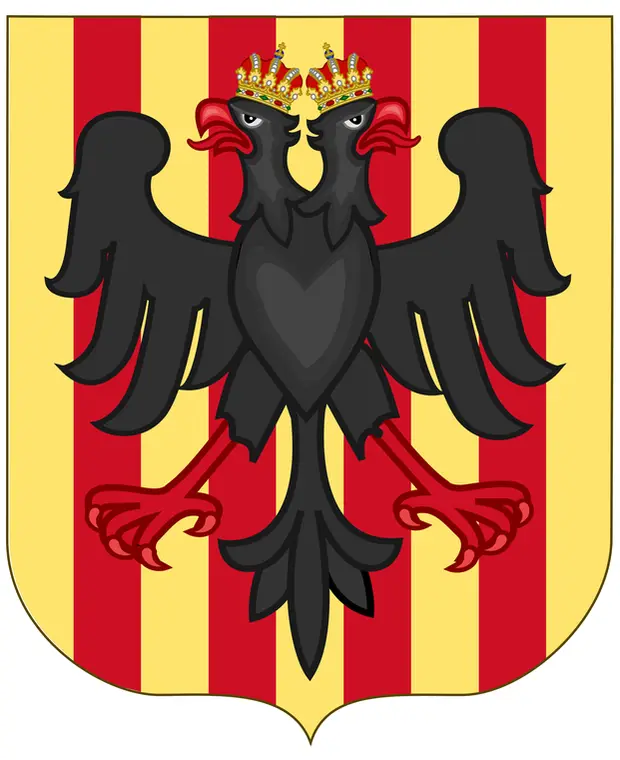
More than that: Altea has no official coat of arms at all. It has never been approved or regulated either by the council or by the Generalitat Valenciana. What exists is customary use — the double-headed eagle attested since at least the nineteenth century, the background with the bars of Aragon only since the twentieth. The town hall today uses a logo showing a crowned double-headed eagle above four red bars on a gold field. We do not reproduce it here.
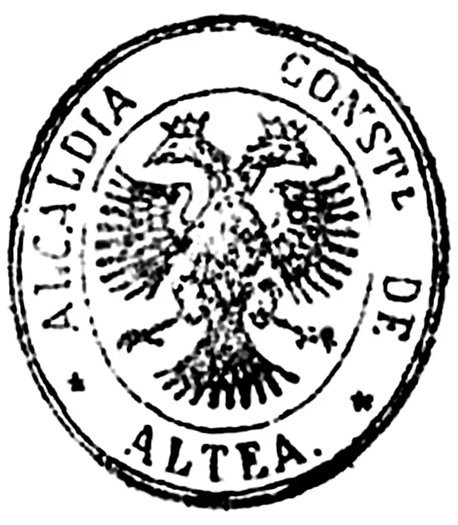
How far back the eagle goes can be dated to the year. A royal order of 30 August 1876 required every Spanish municipality to send in an impression of its official seal; most had arrived by 1878, and the roughly ten thousand impressions are kept today in the national archive as the Colección de sellos en tinta municipales. Altea’s is among them. It carries the double-headed eagle and nothing else — no bars, no shield, just the bird and the legend Alcaldía Constitucional de Altea. The Aragonese bars beneath it came only in the twentieth century.
The development in three steps
- 1876 — On the municipal seal the double-headed eagle stands alone: no shield, no bars, just the bird and the legend. That is where the record begins; nothing earlier can so far be shown.
- Twentieth century — The eagle moves onto the senyera, the four red pales on gold of the Crown of Aragon. Exactly when is unresolved; the answer most likely sits in the local literature.
- Today — The town hall uses that form as its logo: a crowned double-headed eagle above four red bars on a gold field. It was never formally adopted or approved.
Source: written reply from the Arxiu Municipal d’Altea, October 2026. The literature is listed under “Sources”; it can be consulted in Altea’s public library. The newspaper Costa Blanca Nachrichten has told the episode at length ↗, though there the grant is taken as fact without a source.
2. The name: two derivations, one open question
Two explanations compete over where the name comes from, and both have their supporters.
The Greek one traces it to Althaia, roughly “I heal”. It fits the tradition that Greek seafarers named the River Algar for the supposed healing power of its water, and that a Greek trading post of that name stood at its mouth. It is the better story — and the one you will hear most often in Altea.
Behind it lies the Greek althaínein, to heal. The marshmallow plant takes its botanical name Althaea from the same root, as does Althaea, queen of Calydon in Greek myth. None of which proves anything about the town. It only explains why the reading is so persistent: the word really does lead to healing, just not demonstrably to this coast.
The Arabic one traces it to aṭ-ṭalāya, which became talaia in Valencian and atalaya in Spanish: watchtower. The name would then have meant an elevated lookout point — of which this coast had many, against pirates from the sea.
Which is right is not settled. The Arabic derivation is linguistically the more straightforward; the Greek one is older in local tradition. This page presents both rather than choosing.
3. Before anything else: the River Algar
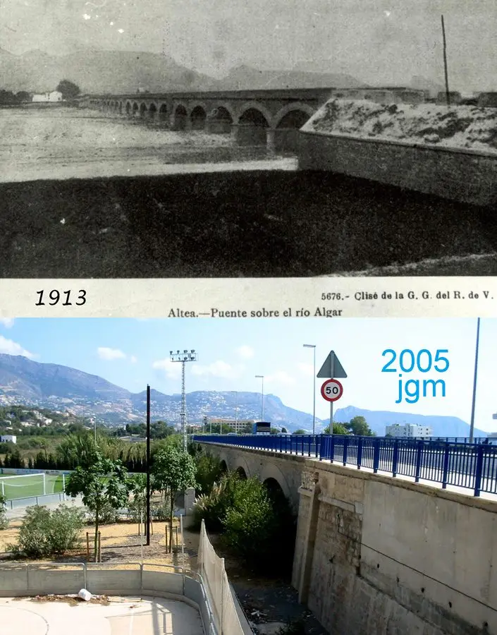
The Algar rises in the hills near Callosa d’en Sarrià, where its springs — the Fonts de l’Algar — remain a destination today, crosses the hinterland and reaches the sea in the bay of Altea.
It is not a river in the northern European sense. For most of the year it carries little or no water; after heavy autumn rain it can become a torrent within hours. That double nature shaped settlement: the fresh water made agriculture possible, the mouth offered a natural anchorage, and the floods kept people from building in the bed itself — they built on the rises beside it.
Early traces of settlement are spread across the whole municipality — rock paintings at the Vicari, Bronze Age finds on the Momai, the Iberian settlement and its necropolis at Altea la Vella. The irrigation system, the Séquia Mare, distributed the Algar’s water across the terraces and made the coastal plain productive. On today’s supply: Water.
4. Iberians, Greeks, Romans
The area was settled long before it had a name that has come down to us. The oldest traces are Neolithic rock paintings at the Vicari; from Iberian times come the settlements at Altea la Vella and on Cap Negret. Greek trade contacts and Roman remains have also been documented around the bay and along the lower Algar.
What is missing is a continuous thread. The finds show that people lived, farmed and traded here; they do not add up to a town with a history. That begins much later.
5. Al-Andalus
Under Muslim rule the area belonged to the lands worked from small farmsteads — alquerías — scattered across the irrigated ground. The name is traced back to the Arabic aṭ-ṭalāya, and the irrigation that later generations inherited was largely laid out then.
The watchtower reading of the name belongs to this era too: a coast under constant threat from the sea kept lookouts on its high points.
6. Conquest in 1244 and three uncertain centuries
In 1244 the area came under the Crown of Aragon. What followed was not prosperity but three centuries of insecurity: raids from the sea, shifting ownership, and after the expulsion of the Moriscos in 1609 a countryside emptied of much of the population that had worked it.
Attempts at resettlement failed because of the insecurity of the time. A tower stood at Bellaguarda; below it, people came and went. Nothing here was permanent enough to be called a town.
7. The refoundation of 1617
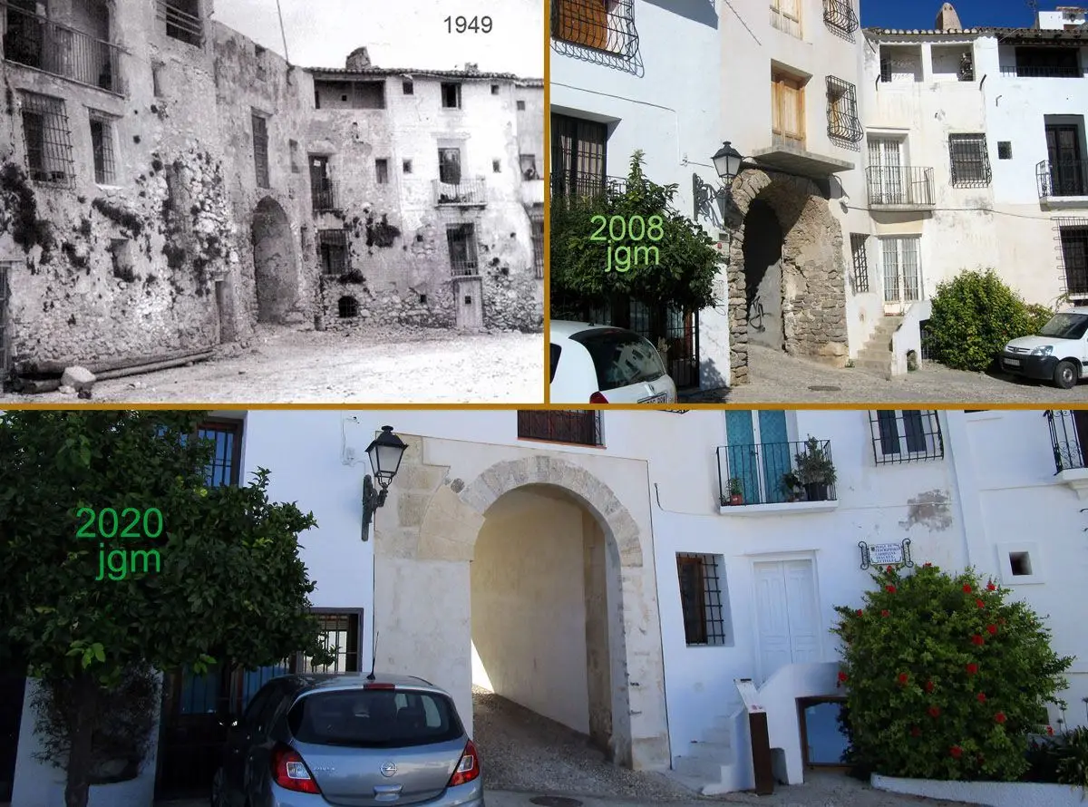
Around the turn of the seventeenth century a small hamlet had held on in the shelter of the tower of Bellaguarda. In 1617, under the lordship of Jaume de Palafox, Marqués de Ariza, it received a second carta pobla: a licence to settle, coupled with the laying out of a walled town on the hill.
That is the birth of the Altea people photograph today. The 1617 plan survives in the street map itself — a grid on the summit, ringed by a wall with originally two gates, the Portal Vell and the Portal del Castell; the Portal Nou was only opened in the mid-eighteenth century. From the Portal Vell, Carrer Major and Carrer Salamanca climb to the church. That the town sits so compact and so high is not aesthetics: it is defence.
After 1617 the settlers also took up the land around the mouth of the Algar. That is how the partides came into being — scattered groups of houses with their own tracks, irrigation channels and chapels. This dispersal explains why the municipality is still a dense core surrounded by widely separated districts: the structure is four hundred years old.
Altea la Vella remained inhabited and is today a quiet second centre with an administrative office of its own.
The 1956–57 aerial survey shows it better than any description: the 1617 town sits almost alone on its hill, surrounded by the scattered partides and the terraces of the Algar. What came afterwards — the slopes, the housing estates, the coast road — is the story of the last seventy years. 1956–57 aerial survey in the Generalitat’s map viewer ↗
8. Raisins, fishing and the long nineteenth century
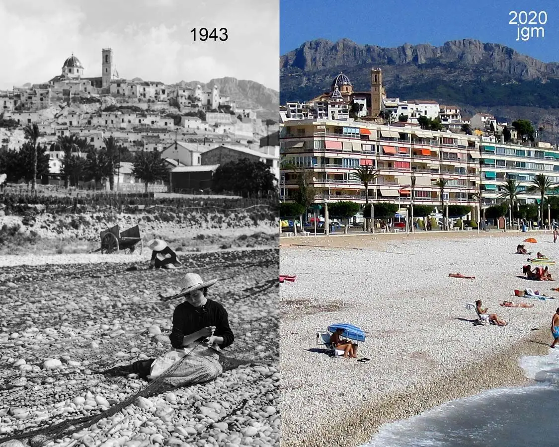
From the eighteenth into the early twentieth century Altea lived off agriculture: almonds, carob, wine and above all raisins, shipped north through the coastal harbours. The botanist Cavanilles described the district in the late eighteenth century as carefully irrigated cultivated land — the achievement of the Séquia Mare.
Fishing was the other mainstay. As all along the coast, phylloxera and the raisin crisis hit Altea too. Into the 1950s Altea remained a place that lived off the sea and off narrow terraced fields.
9. The artists, then the tourists
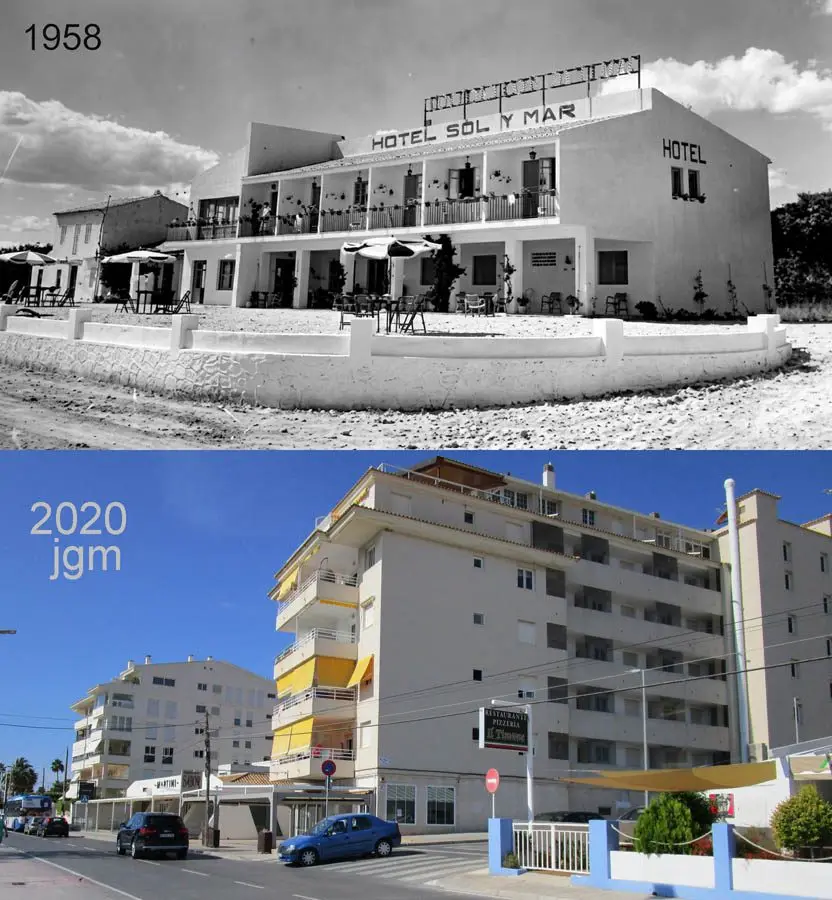
From the 1950s and 60s painters, sculptors and writers discovered the town. That artists’ colony still sets Altea apart from its neighbours: it brought galleries, an audience and, more importantly, a way of seeing itself that rejected the towers.
When mass tourism transformed the coast in neighbouring Benidorm, Altea kept its buildings low. That is one reason why two towns ten kilometres apart look so different. Later came a faculty of fine arts, the Palau d’Altea and a settled international population: today around a third of registered residents were born outside Spain.
10. What can still be seen today
- The 1617 plan — the grid of the old town, the Portal Vell and the remains of the wall
- The church of the Mare de Déu del Consol — the blue-and-white domes came with the new church, built from 1901 and blessed in 1910 — more recent than most people think
- Torre de Bellaguarda — watchtower beside the oldest quarter, now a viewpoint
- Torre de la Galera — listed monument from the era of coastal watch
- The double-headed eagle of the arms — borne by custom, not by grant
- The partides — the dispersal of 1617 turned into today’s districts
- Altea la Vella — the original site, today the second centre
- The Algar with the Séquia Mare and the irrigation channels inland
Once you have seen how all this connects, you read the town differently: the hill is a fortress, the dispersal is an agrarian structure, and the river is the reason for both.
11. Sources
This account is a summary for everyday use, not a work of scholarship. It draws on:
Research and archives
- “Altea en la Edad Moderna” — research blog on local history at the Universidad de Alicante, blogs.ua.es/historiaaltea. Basis for the 1617 carta pobla, the Palafox lordship, the formation of the partides and early modern agriculture.
- Antonio José Cavanilles, Observaciones sobre la historia natural, geografía, agricultura, población y frutos del Reyno de Valencia, 1795–1797 — a contemporary description of the irrigated land.
- Arxiu Municipal d’Altea — for the original documents; accessible through the town hall. Its photographic collection is small and not digitised; for pictures the archive itself refers to Altea Mi Pueblo.
- Altea Mi Pueblo — private collection of historical photographs of Altea, alteamipueblo.es ↗.
On the coat of arms
The basis is a written reply from the Arxiu Municipal d’Altea of October 2026, together with the literature the archive itself names — available in Altea’s public library:
- BARRANQUÍ: “El escudo heráldico de la villa de Altea”, in Fiestas Santísimo Cristo del Sagrario y Patrón San Blas. Altea, 1978.
- “Escudo de Altea”, in Revista Altea, 1998, no. 227, pp. 22–23.
- GIMÉNEZ LÓPEZ, Enrique: “El desembarco aliado de Altea de 1704 y el virrey Marqués de Villagarcía”, in Homenatge al doctor Sebastià García Martínez. València: Generalitat Valenciana, 1988, vol. 2, pp. 269–284.
- GUTIÉRREZ DEL CAÑO, Marcelino: Monografía histórica de la Villa de Altea. Altea: Aitana, 1998, pp. 63–70 (facsimile of the Valencia 1920 edition).
- LLORENS BARBER, Ramón: Diccionario de Altea y sus cosas. Altea: Revista Altea, 1983, pp. 175–191.
- Archivo Histórico Nacional, Colección de sellos en tinta municipales — seal impressions sent in by municipalities under the royal order of 30 August 1876; among them the seal of the Alcaldía Constitucional de Altea.
Official data
- Ajuntament d’Altea, altea.es — coat of arms, monuments and presentation of the municipality.
- Instituto Nacional de Estadística, ine.es — population and the share of residents born abroad.
On the place name
- “Los orígenes de Altea, lugar de sanación o atalaya ante los invasores”, AQUÍ Medios de Comunicación, 2021 — sets the two hypotheses against each other.
- Spanish Wikipedia, “Altea (Alicante)” — starting point and cross-check of dates; not an independent source.
Sources for individual sections
- PÉREZ I APARICIO, Carme: “La guerra de successió i el bloqueig de Dénia del 1705”, in Aguaits 24–25 (2007), pp. 21–47, raco.cat — the fleet off Altea in 1703 and 1704, its departure from Alicante, the landing of Valencian supporters of the Archduke at Altea and the handover of Dénia on 18 August 1705 (pp. 22–24).
- ADRADOS VILLAR, E.: “Los fondos sigilográficos del AHN”, webs.ucm.es — the seal collection assembled under the royal order of 1876.
- “Altea en la Edad Moderna”, individual posts: origin of the name, the Middle Ages (taifa of Dénia, conquest of 1244, first settlement charter of 1279), the War of the Succession, fishing (mid-eighteenth century).
- BORJA I SANZ, Joan: Toponímia dels pobles valencians 241: Altea, Acadèmia Valenciana de la Llengua, 2021, avl.gva.es — rock paintings at the Vicari, the Iberian necropolis of Altea la Vella, the main settlement there until the seventeenth century; the carta de poblament of 11 January 1617, granted by Jaume de Palafox.
- MARTÍNEZ GARCÍA, J. A.: “Terme municipal d’Altea”, in Actuaciones arqueológicas en la provincia de Alicante 2001, MARQ, marqalicante.com — finds on the Momai, Iberian and Islamic finds in the old town, whose medieval tower-fortress remained in use until the seventeenth century, the Iberian settlement on Cap Negret, the Torre de la Galera as a sixteenth-century watchtower.
- Turisme Comunitat Valenciana, “Torre de Bellaguarda”, comunitatvalenciana.com — a coastal lookout in the sixteenth century.
- BOE-A-2012-4840 — opening of the procedure to declare the historic centre a Bien de Interés Cultural, boe.es; it records the Islamic origin of the Bellaguarda fortress, the wall’s two original gates and the Portal Nou opened in the mid-eighteenth century, and the building of the present church from 1901 and its blessing in 1910.
- PATRICOVA, Decreto 201/2015 of the Consell, the plan for flood-risk prevention, datos.gob.es.
A note on method
Much of what circulates on the internet about Altea’s history — on hotel websites, travel portals and encyclopedias — reproduces the same short text word for word. That a fact appears on twenty sites does not prove it true: those are not twenty independent sources but one copied twenty times. This affects the etymology of the name above all.
Here only archival work and the specialist literature count as sound. Where they disagree — the origin of the name, and the nature and location of the Greek settlement — the disagreement is left on the page and not resolved in favour of the prettier version.
Compiled October 2026. Where dates are uncertain they are given as approximate; where a claim rests on local tradition rather than record, it is described as such.