1. First things first
July and August are not walking months. The mountain paths have no shade and become dangerously hot by midday. If you go in summer, go at first light or not at all. The best time is March to June, then October and November.
- Water — a litre and a half at least, even on short routes. On most routes there is none on the way.
- Proper boots — the limestone is sharp and slippery at once. Trainers will do for the promenade, not for Bèrnia.
- Check the fire risk level — at level 3 (extreme) the regional government bans walking on footpaths by resolution. The level is published on the regional emergency portal.
- Phone signal disappears in places in the ravines. Download the route first.
2. One to two hours
- Morro de Toix — the best effort-to-reward ratio in the area. 2.85 kilometres there and back, 81 metres of ascent, about forty minutes. At the top: the bay of Altea to the south, the Penyal d’Ifac to the north and the Mascarat gorge below. The classic sunset spot, but set off in good time.
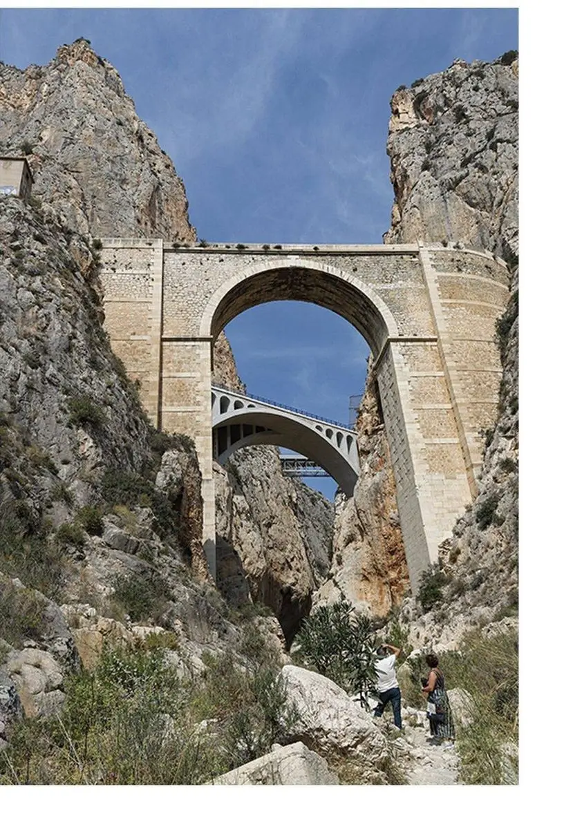
- Mascarat gorge — into the canyon from the bed of the ravine, about an hour, manageable with children. You pass beneath the road, railway and motorway bridges; since 2025 the trains have run over a new viaduct. The history of the gorge
- Old town circuit — Portal Vell, Mirador Blanco, the church square and back down Carrer Major. An hour, but steep; in summer, in the evening.
- Coastal path towards Albir — flat, beside the water, passable with a pushchair as far as the municipal boundary.
- Cap Negret — the black volcanic rock north of the town, a fossil beach and three harbour basins under dispute. More on Cap Negret
3. Half a day
- Forat de Bèrnia — the natural tunnel through the ridge, a hole in the rock you climb through to reach the far side and look down on the bay of Altea. Start at the Cases de Bèrnia above Benissa. Moderate; proper footwear needed.
- Río Algar — 11.6 kilometres, about three hours, almost flat. It follows the river through the market gardens, past the Molí dels Moros. One of the five municipal routes. The railway crosses the Algar on a new viaduct; the old one beside it is being kept as a footbridge.
- Fonts de l’Algar — the springs near Callosa d’en Sarrià, with waterfalls and natural bathing pools. There is an entrance charge and it is very busy in summer; go early or out of season.
- Albir lighthouse — a broad, well-made track inside the Serra Gelada nature park, with the lighthouse above the sea at the end. Suitable for families.
4. A full day
- Bèrnia circuit, PR-CV 7 — the classic walk of the province. Some ten kilometres around the ridge, with the Forat on the north side and the Fort de Bèrnia on the south, a sixteenth-century fortification. Four to five hours, around 800 metres of ascent depending on where you start.
- Bèrnia summit — 1,129 metres, with scrambling and chain-assisted sections along the crest. Only with experience and a head for heights. On a clear day the view runs from Dénia to Benidorm, and as far as Ibiza.
The Serra de Bèrnia has been protected since 2006 as the Paisaje Protegido de la Sierra de Bernia y Ferrer (Decreto 103/2006), on the territory of Benissa and Xaló. The ridge runs for some nine kilometres at an average height of about 900 metres, a few kilometres from the sea — hence the curious sense of high mountains directly above the coast.
5. Cycling, climbing, motorcycling
- Road cycling — the coast road to Calp over the Mascarat is the standard loop; inland, through Callosa and Tàrbena, it becomes serious. The area is a well-known winter training ground.
- Mountain biking — the tracks along the Algar and the dirt roads below Bèrnia. The ridge itself is walking country, not for bikes.
- Climbing — the Agujas del Mascarat have bolted multi-pitch routes. Local knowledge or a guide is needed; this is not beginners’ ground.
- Motorcycling — the run through Callosa, Tàrbena and the Coll de Rates counts among the finest in the province. Busy at weekends accordingly.
6. The municipality’s own routes
Altea has five waymarked paths through its territory, with a leaflet to download — among them L’Algar. L’inici de l’horta alteana, Quintanes i Barranquet and Cap Blanch i els Arcs. They are shorter and flatter than the mountain walks, and explain what you are looking at along the way.
7. Where to find more
For route descriptions with maps, elevation profiles and photographs, two private sites are considerably better than anything official:
- linkalicante.com — detailed accounts of nearly every route in the province, with an assessment of the difficulty
- sendasyleyendas.com — an overview of the paths in and around Altea, with distances and times
Both are private and independent; we link to them because they are good, not because of any arrangement.
Compiled October 2026. Distances and times come from the linked sources and are approximate. Path closures, fire risk levels and the state of the tracks change — check before every outing. Further sources: path closures at level 3 alicante.es; Mascarat viaduct alicanteplaza.es; Fort de Bèrnia callosa.diputacionalicante.es; protected landscape, ridge and summit height dogv.gva.es; Fonts de l’Algar admission lasfuentesdelalgar.com; Algar viaduct alicanteplaza.es; climbing in the Mascarat macma.org; Cap Negret fossil beach (Decree 181/2020) mediambient.gva.es, harbour concessions per the sources on the Cap Negret page.